Waipohatu walking track and waterfalls

I’m a big fan of the Catlins. As a landscape photographer I feel it offers plenty of locations for interesting photography. I’m not sure I love waterfalls all that much, but, I really enjoy walking through pristine New Zealand native bush. In the case of the Waipohatu walking track, you not only get a lovely bush walk but two waterfalls to photograph. How could I resist.

Getting There

The Waipohatu walking track is located on the way to Curio Bay. Just take a detour toward Slope Point and then drive up Waipohatu Rd when it pops up on your right. I parked up at the picnic spot (with toilet) and started my walk from there.

Trees near where I parked my car on the Waipohatu walking track.

Stage One: A gentle stroll.

The first part of the walk includes the most photogenic bush of the adventure. The walk has been designed to accommodate wheelchair access so is very well constructed. I was very taken with this suspension bridge.

No more than 5 at a time over this suspension bridge.

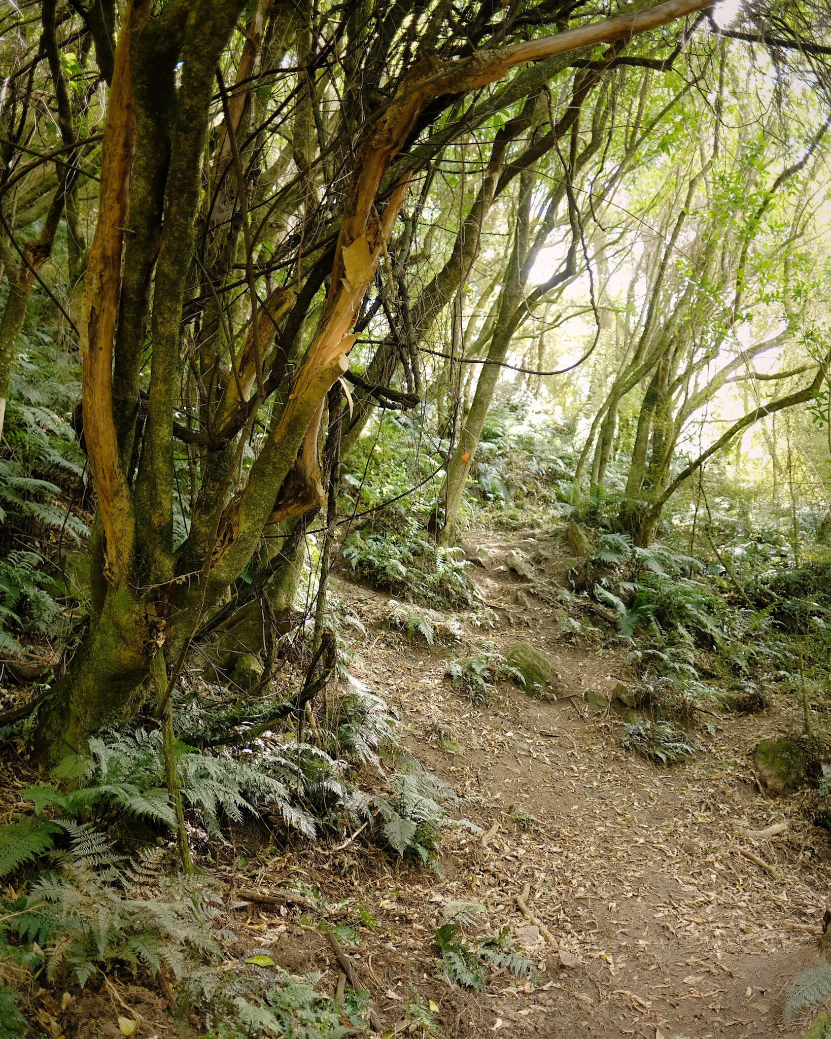
The pathway was wide and user friendly with lovely large trees lining the route.

Waipohatu walking track.

Stage Two: An uphill slog.

After walking through the easy meandering track you come to a picnic area and then move on to the next part of the track. From this point the track becomes much more challenging. The track has plenty of tree roots, so watch your footing.

Follow the orange arrows on the Waipohatu walking track.

The track follows along a stream and eventually you get to cross it on this rather cool bridge.

After crossing the bridge the track climbs fairly steeply. if you have average fitness you should be fine, but it definitely got my heart rate going.

Stage 3: Waterfalls

After climbing for a while the track eventually flattens out and then dips down again toward the waterfalls. You will come to a juncture where you can go left or right. Both tracks lead to a waterfall. It has to be said that 2 for the price of one is always an attractive deal. I went right to the upper falls first.

Waipohatu waterfall, Catlins, Otago, NZ.

The lower falls are really nice. A bit tricky for navigating the area, but that’s half the fun. I took a couple of images of the waterfall. In one I used the stunning ferns in the foreground to add depth. The image shows the young fronds coming through the centre of the plant creating the beautiful koru shape found in traditional Maori culture.

Waipohatu waterfall, Catlins, Otago, NZ

Waipohatu waterfall, Catlins, Otago, NZ.

The trip out of the bush, was a lot faster as it was downhill for the first part. The DOC signs estimate about 2 hours for the walking, and seemed about right. All in all the Waipohatu walking track is a lovely day out. If you have reasonable fitness and are coordinated enough to navigate an uneven track with sludge and tree roots you should be fine.

Catlins River Track

I was in the waiting room of Mercy Hospital recently and on a coffee table was a book by local artist Murray Ayson. Murray’s paintings of Otago scenes were so beautiful. I was saddened to learn he had only just recently passed away, A few days later I bought a copy of the book from the Art Society in the Dunedin Railway Station. I plan to use it as inspiration for photography adventures in Otago. The first inspired journey from his paintings was the Catlins River walk.

Beautiful steps on the Catlins River walk track.

The journey to the Catlins river walk from Dunedin takes just under 2 hours. Access to the track is via the Tawanui Campsite, so head to Owaka, then depart the Scenic Southern route and take the Owaka Valley road, I got google maps to direct me from there.

I was unaware of heavy rainfall the night before so my visions of a tranquil and relaxing river walk were shattered completely. The river was a muddy and swollen mass, roaring with anger.

Catlins river after heavy rainfall the night before.

Catlins river after heavy rainfall the night before.

I wasn’t keen on gong anywhere near the waters edge as one slip could prove fatal. My river walk would instead need to focus on the rainforest. It was still raining and I was getting a right old soaking. I took an umbrella with me, and used it to cover my camera bag anytime I stopped to take a picture. The track is easy to follow and has some lovely small bridges and steps created to make the journey easier. I couldn’t get over how lush and green everything was. The moss lining the track was the most luminescent green I have ever seen.

Vibrant green moss lined track on the Catlins river.

Vibrant green moss lined track on the Catlins river.

There was so much water about, often the steep pathways had a flow of water, so I would recommend waterproof hiking boots if you take the track on a wet day. I also used a leg of my tripod as a makeshift hiking pole along with the umbrella to help keep me on the track. I am fairly sure this next image of a small waterfall would be nowhere near as impressive on a dry day.

After a night of heavy rain a small tributary on the Catlins river is turned into an impressive waterfall.

After a night of heavy rain a small tributary on the Catlins river is turned into an impressive waterfall.

The highlight of the adventure was seeing giant trees covered in moss. They were like something out of Lord Of The Rings, truely magical. These are the sort of trees photographers dream about, throw in some mist and I’d be a very happy camper.

Moss covered trees on the Catlins river track.

The track crosses the river a few times, but I turned around before I reached the first over-bridge after about 9000 steps as I knew I would be mucking about taking pictures on the way back. It was a real pleasure to be out in some pristine unspoilt rainforest, around every corner there was something new to appreciate.

A sea of ferns just off the Catlins River track.

A sea of ferns just off the Catlins River track.

The Catlins river track is definitely a path I will tread again, as I am curious about seeing how it looks in different seasons. I can highly recommend this adventure to any nature lover, just be prepared for wet weather.

Woodside Glen Track

Woodside Glen is located at the end of Mountain Rd, a few minutes drive from Outram. The first part of the track is easy going and most people should be able safely manage the stroll down to Lee Stream.

Arching trees near the start of Woodside track.

Arching trees near the start of Woodside track.

View from the Woodside Glen track

View from the Woodside Glen track

Once you reach Lee Stream, you need to cross it to continue on. A quick hop, skip and jump over a few rocks is all the skill required, just avoid those green slimy rocks.

Lee Stream, Woodside Glen Track.

Lee Stream, Woodside Glen Track.

Walk over the foreground rocks of Lee Stream to access the next part of Woodside Glen Track.

Walk over the foreground rocks of Lee Stream to access the next part of Woodside Glen Track.

The next part of the track is a very steep climb. There is a sign warning only advanced hikers should carry on. I agree, as it was easily the most steep incline I have walked up, and it went on and on. The trail gets a little harder to follow, but just make sure you follow the orange arrows and you can’t go wrong.

Orange arrows line the track pointing you in the right direction.

Orange arrows line the track pointing you in the right direction.

The steep pathway goes up and up!

The steep pathway goes up and up!

Woodside Glen Track

Woodside Glen Track

A young native tree catches sunlight.

A young native tree catches sunlight.

After about 2 hours and around 6000 steps I cleared the bush cover and the landscape changed to tussock grass with large rock formations.

Woodside Glen Track.

Woodside Glen Track.

Exposed nature of the land above the tree line on Woodside Glen track.

Exposed nature of the land above the tree line on Woodside Glen track.

From above the tree line you can see below to the Taieri Plain, with Saddle Hill and the Pacific Ocean beyond. Up here you can be exposed to the elements so make sure you have a warm jacket.

View of Saddle Hill from Woodside Glen.

View of Saddle Hill from Woodside Glen.

I walked as far as I could follow orange markers and then decided to turn around. From this point I believe the Maungatua Summit Track continues. Going down, while quicker, is also challenging. In total I walked about 11500 steps by the time I reached my car. Woodside Glen is a hard track to climb but highly rewarding when you see the end view.